When you look at the intersections of health and urban form, one of the most important considerations is how walkable your urban environment is. A walkable environment has been shown to induce more physical activity and reduce obesity, some types of cancer, and general mortality. The more places a person can walk to, the less carbon their transportation consumption puts out as well, which affects global health. All of this makes assessing walkability extremely important as it can have profound implications on personal and public health.
Any tool that seeks to assess walkability on a mass scale with just data will tend to be flawed in some form. Most walkability assessment tools are centered around the density of amenities and housing (including my own). While this does a good job of giving you a general idea of things, you can never really know how walkable a given area is until you walk through that area yourself. This is because many factors that contribute to walkability are either not available en masse as data or are more subjective and difficult to measure in the first place.
The most popular walkability assessment tool is WalkScore by Redfin. This tool is meant to be used by the real estate industry, so it's inherently a little different, but it’s widespread use makes it worth taking a look at. WalkScore gives Downtown Louisville a score of 82, making it the second most walkable neighborhood behind Phoenix Hill. The map below shows the parts of Downtown with the highest ranking.

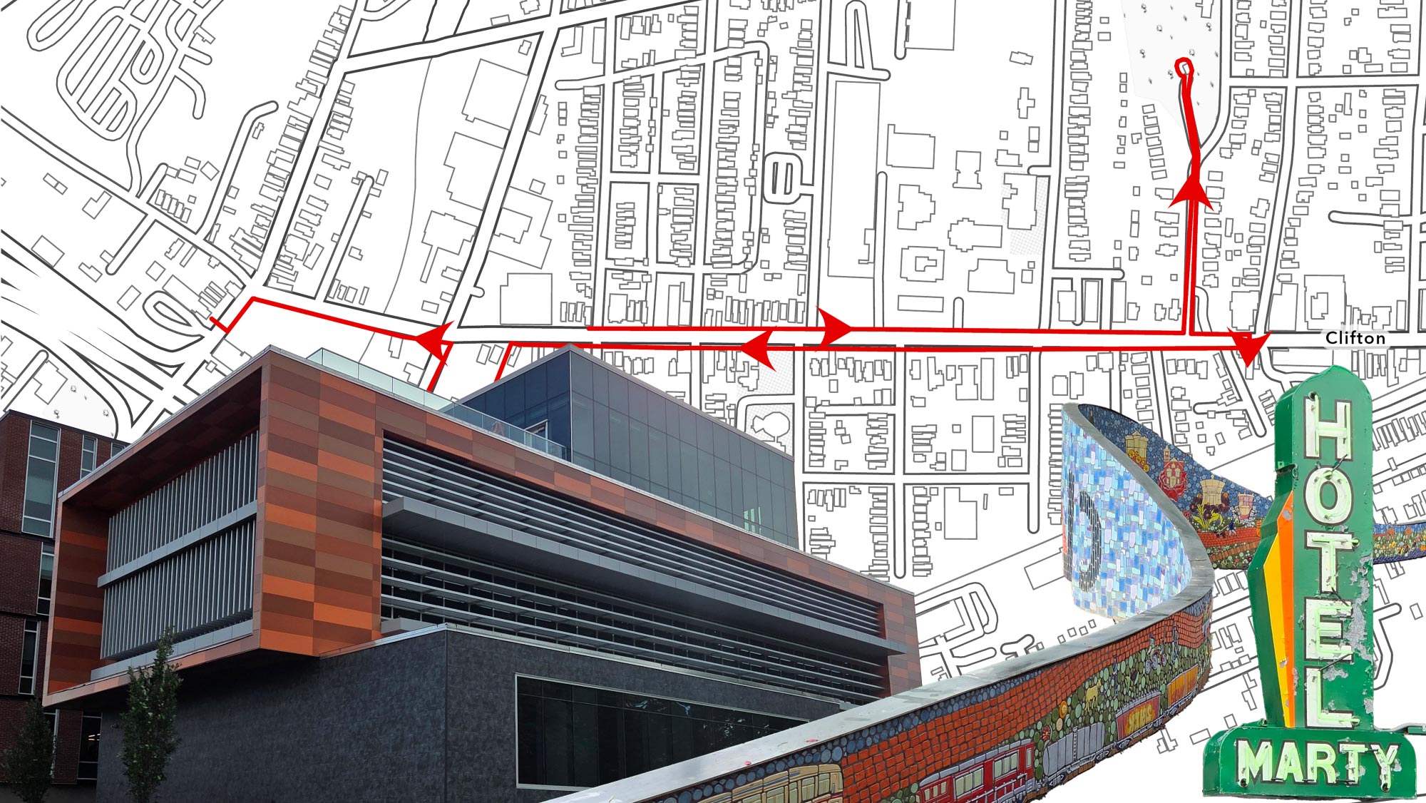
Based on this map, you would be inclined to believe that W. Liberty Street has the most pedestrian friendly streetscape of any road Downtown. The street likely ranks so high because it is surrounded by some of the more walkable streets, but this would not be obvious to someone who does not have any experience with this kind of measurement. So let's take a walk down this corridor ourselves and see what issues arise that may conflict with walkability.
The segment of Liberty we are looking at is between 7th and 1st Street, and one of the first sets of buildings you see as you walk this corridor from 7th belongs to the Louisville Department of Corrections. Immediately the largest issue with this corridor becomes apparent: a lack of engaging frontage. Frontage being the eye-level part of buildings you will walk by as a pedestrian. The Department of Corrections buildings are (understandably) not very engaging as you walk by, but this reoccurs across Liberty. Unfortunately, I was not able to get a good picture as I did not want to be taking pictures of a jail in front of a bunch of police officers.

Frontage plays a critical role in walkability. It is often the most interesting part of any walk, and a walk needs to be interesting for people to commit to it. Throughout the corridor, many of the buildings simply had nothing at eye-level that was engaging. Either they were blank walls or vacant businesses. The only major exception to this is The Omni, the Liberty side of the building contains a variety of businesses that create an engaging environment.


Some buildings had boring frontage, but some portions of Liberty also consist of large surface parking lots. These do not contribute to an engaging streetscape and often pose danger to pedestrians as cars exit and enter.

Two other important factors that cannot be measured with easily available data are perceived safety and comfort. Perceived safety along this corridor is (subjectively) fine, street parking lines the entire road and provides a barrier between you and the often speeding cars. Street trees also play an important role in slowing vehicles and reducing urban heat. While there were a decent amount of street trees, some segments were completely barren and unbearably hot on the 95 degree day I was out there. The heat is also reinforced by the presence of large impervious surfaces such as parking lots.
Accessibility can also pose a significant barrier for those with physical disabilities. This portion of Liberty does not contain any bike lanes, so all types of mobility aid users will be on the sidewalk. Luckily, the sidewalk is mostly in a good state of repair. Although, some of the curb ramps approaching crosswalks are not ADA compliant, meaning blind or sight-impaired pedestrians could walk into the street without realizing. This includes the at 2nd Street, which is the busiest road that intersects with Liberty along this corridor.

2nd Street also brings us to another hard-to-measure component: enclosure. Humans are naturally evolved to seek prospect and refuge, meaning we want to be able to see out into a space (prospect) while also feeling relatively safe and confined within it (refuge). The ideal ratio for this is disputed and not necessarily universal, but large roads and surface parking throw the ratio of this way off regardless of the ideal. The presence of 2nd Street and significant surface parking along Liberty can periodically ruin your sense of enclosure and make you feel less inclined to walk around here in the future.
Along Liberty is a street that contains a significantly more ideal environment for pedestrians, 4th Street. The stretch of road north of Liberty has relatively wide, well-maintained sidewalks. Street parking, street furniture, and street trees make you feel safer and more comfortable. The area is also well enclosed, accessible, and has a significant amount of engaging frontage that makes walking through a pleasant experience. On the south side is Fourth Street Live, an entirely pedestrian and largely shaded area. If you are looking for model streets in Downtown Louisville, this is about as ideal as you can get.

While this post is mostly picking apart the WalkScore system, these flaws are not remotely unique. The EPA has their own national walkability index that assigns scores on the census tract level. Once again, it can be *generally* accurate but the design leads to some issues such as Spaghetti Junction being put into the “most walkable” category.

There are other issues arising in these walkability scoring/indexing tools, but these are just some prominent examples. This post doesn’t exist to *debunk* these kinds of spatial tools. They serve a good purpose to provide a general overview, but ultimately on-the-ground work is necessary in order to really know what is needed to make an area more walkable and pedestrian-friendly. There are walkability audits available online, such as this one from AARP, that can be utilized to assess walkability on a street-by-street basis.