We recently published an article covering the history of the Hotel Watterson, as construction crews uncovered portions of its foundation. This hotel was one of many buildings torn down during the 1900s; urban renewal, reorientation towards office and commercial construction, and the shift to car-centric transportation led to a dramatic shift in the urban form of downtown. Hotel Watterson had a rich history by itself and held an important place in Louisville’s past. This made us curious about the history of the greater area surrounding the New Vision of Health Campus and how the urban form has changed over the past century or so.
Mapping the Area
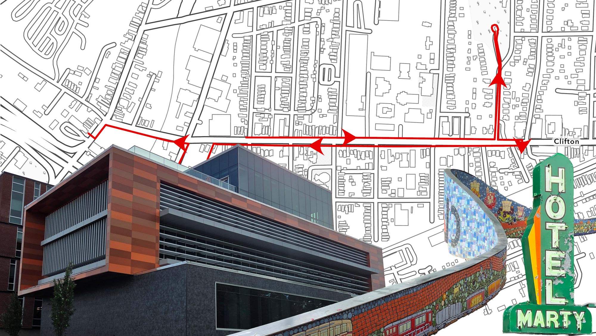
A New Vision of Health Campus is located at the corner of 5th and Muhammad Ali, and is the future home of the UofL Christina Lee Brown Envirome Institute. The campus is positioned in the heart of downtown, and is surrounded by significant historic structures such as the Louisville Gardens, Kentucky Towers, and Seelbach Hotel. The campus itself will consist of two historic buildings formerly known as the Republic and Harmony buildings. Given the historic buildings we can see, there is likely a good amount of demolished history near to the campus. In this piece, we will be looking at the history within two to three blocks of the campus.

Louisville 1905, a UDS project from 2018, unveiled how much of Louisville was demolished throughout most of the 20th century using 1905 Sanborn maps.
Sanborn maps “...were designed to assist fire insurance agents in determining the degree of hazard associated with a particular property and therefore show the size, shape, and construction of dwellings, commercial buildings, and factories as well as fire walls, locations of windows and doors, sprinkler systems, and types of roofs. The maps also indicate widths and names of streets, property boundaries, building use, and house and block numbers.” - Library of Congress
Sanborn also had a set of maps that documented Louisville in 1940, which shows many of the historic buildings that would soon be torn down during urban renewal. 1940 also provides some interesting insights, as cars are becoming more common during this time but have yet to start dominating transportation. These maps were used to create building footprints for the study area. We can utilize these footprints and information from the Sanborn maps to see how the urban form and land use has changed over time.

1940 vs 2022 Building Footprint Comparison
One of the most apparent differences is the size of the buildings. In 1940, Downtown’s buildings were much smaller generally. This results in a large difference in the total number of buildings, with 1940 having 313 and 2024 only having 60. Only one building in 1940, Louisville Gardens, takes up a significant portion of one city block. This is a time where central air conditioning did not exist, so block-wide office towers were not really feasible. This also results in there being more “mid block” areas, resulting in the interior of the city blocks being much more accessible. Many of these mid-block areas were parking or storage, but some allowed access to alley apartments and small courtyards.
Speaking of parking, there was a lot less of it in 1940 when compared to today. Lots were generally smaller and fit only 30 or so cars. Over the next few decades, parking lots would take over large portions of the city. The blocks between 6th and 7th street are the best examples. The 600 block of Muhammad Ali had 50 different structures on it, now it has one and is mostly just a large parking lot. Some blocks were completely wiped for parking such as that of the Mud Lot on Ninth Street, although that is outside the study area. Within the study area, around 94 structures were demolished to make way for surface lots.
A major change in land-use is the moving of amenities to the suburbs and the centralization/corporatizing of these amenities. In 1940, there were multiple movie theaters and play theaters within this study area. Now there are none. These were small, and likely only had one or two screens/stages as opposed to the 4+ you may see in larger theaters now. There were also multiple clubs, schools, general stores, laundry facilities, and more that have been lost to time. Many of these were located in mixed-use structures, with offices or apartments on higher floors. Since 1940, Downtown has moved significantly more towards single-use structures.
What Was Lost
The Sanborn maps can give us a general overview of what was demolished during the 20th century, but they cannot really tell us why so many buildings were torn down. Luckily, many of these areas had their demolition recorded for one reason or another by the Courier-Journal, so we can use their archives and archives from the University of Louisville to figure out why so many of these buildings disappeared. We can also use other archival information to figure out the history of these buildings in some capacity while they were still standing.

No block represents what was lost to parking better than the 600 block of West Muhammad Ali Blvd. The picture above was taken in 1959, just a few years later, most of the block would be bulldozed to make way for parking for the new “civic center” as part of urban renewal. The large brick building, the Grand Theater, would survive for a few more years. The block now consists of a singular government building and large surface parking lot, replacing over 50 buildings existing on the block in 1940.
Just north of the Grand Theater was the R.E. Jones Temple Methodist Church, a large black-only church that was flanked by apartments to its rear. Little recorded information seems to exist about this church, other than that it relocated in 1950. Despite its size, there seem to be no pictures of the church in any online archive’s we searched.

The “civic center” extended further north, clearing out buildings all the way to Jefferson Street. This is now where the Department of Corrections and Hall of Justice are located. These two large buildings replaced around 29 smaller structures, including the Jefferson County Auxiliary Armory. This armory was built in 1923, and utilized by the 138th Field Artillery Brigade for several years, after which it became storage and shifted between several potential buyers. It was eventually torn down at some point during urban renewal, although no exact date could be found. This is the lot where the Department of Corrections is currently located.

South of Muhammad Ali, multiple blocks had significant chunks of their structures wiped out for parking as well. One of these included the National Theater, which had a history more complicated than most. The large and ornate structure was completed in 1913, but only survived for four decades despite being one of the higher-capacity venues downtown. On its opening night, the main star of its first play failed to show. Rumors were that this was caused intentionally by B.F. Keith, a rival theatrical circuit. This feud between the National and B.F. Keith would define the theater’s first few months until B.F. bought out the venue in 1914.

From this point on, the theater would vary between uses, playing live shows and new-fangled motion pictures. There would still be visits by well-known actors and sold out shows, but the B.F. Keith circuit still floundered, eventually dropping the National Theater from its retinue. After this, the theater would flounder between different uses showing motion pictures, tabloids, and even burlesque shows. Later on, it became a black only movie theater during segregation, a period where Walnut Street was a cultural center for African Americans in Louisville.
The National would be torn down in 1952. This was before urban renewal was official policy, but this was essentially the early stages of it. The National was among several buildings in the largely African-American area to be torn down during this time to make way for more parking. There were plans for the lot to become a 400-spot parking garage, but it remains a surface lot to this day.

The lot opposite of where Louisville Gardens stands today was also cleared as part of the city’s parking initiative in the 1950s. In 1940, this northern portion of the long block between Chestnut and Walnut only had a few structures remaining. The southern portion of this block has remained relatively similar since the 1940s. Most of the radical change occurred during the 30s, where some buildings were demolished to make way for the Southern Bell Telephone Company Building (now owned by AT&T). Some residences and businesses were located there.

The largest building torn down on this block was the George D. Prentice school, also known as the Eighth Ward school, in the middle of the block. Prentice served special needs students until its demolition in 1972. The structure had stood here in some form since 1832, and was one of the oldest in Louisville. It functioned as a school, civil war hospital, and the Kentucky School of Medicine Hospital and Dispensary. In 1971, it was sold by the Board of Education to the Southern Bell Telephone company, who constructed a new electronic switching office that stands there till this day. The “new” three story building was originally designed to accommodate the addition of nine extra stories, but these were never constructed.

On the opposite side of Sixth Street, the neighboring block would share a very similar fate. The historic J.M. Weaver Memorial Baptist Church, at the corner of Seventh and Chestnut, was torn down in the mid 1960s. This would eventually make way for the new regional HQ of the Southern Bell Telephone Company. This church was well over 100 years old, and was demolished along with a variety of homes that would not look out of place in Old Louisville today. This HQ would eventually fall under ownership of AT&T, and is now planned to be the new HQ for the Louisville Metro Police Department.


The eastern side of the study area generally went through less change compared to the western side. Some of the buildings around in 1940 were at least partially preserved, but many were still carved out. The Republic and Harmony Buildings, the soon-to-be A Vision of Health Campus, were almost demolished as part of a third phase for the downtown Galleria development. The Watterson Hotel was demolished to make way for this phase that was never built. The Galleria appears to have been a major contributor of change in this area in the late 20th Century.

A large office building at the corner of 4th and Walnut was demolished to make space for the future Medinger Tower. This building was home to H.P. Selman and Company. H.P. Selman and Company was a Louisville-based, high-end fashion company that primarily catered to women and children. The successor brand, Gus Mayer’s, does not seem to exist any more.
At the corner of 4th and Liberty was the Woolworth Company Building. This building was also torn down and eventually replaced by a portion of the Galleria/Fourth Street Live!. Woolworth was founded in 1879 in New York, and was once one of the largest retail chains in the nation. The brand faced the same fate of many mass-market retailers, slowly fading as the 90s approached. In order to survive, they reoriented and renamed themselves after their most successful brand: Foot Locker. Despite this, some remnants of the old Woolworth exist in Mexico.

The buildings and history discussed so far is not comprehensive. There are hundreds of lost structures in the study area that were wiped away. This mostly just covers the larger buildings with history that is relatively accessible. Much more history could be uncovered with further research and engagement with sources that do not exist online. The mapping could also be much more extensive, as Sanborn mapped much of Louisville’s urban core. There is potential for this to become a more expansive research project covering significant portions of the city, but for now, this is the extent of the research for the sake of brevity.
The urban form of the 1940s was not perfect, it was likely not great for people’s health that we had a good amount of industry downtown close to offices and residences. Despite that, looking at this history and how our city has changed gives us a glimpse into what a denser, more walkable Louisville looked like and could look like in the future. It also lets us look at how structural racism has impacted Louisville’s design, with urban renewal clearing swaths of land that once contained thousands of homes and businesses. When it comes to creating a more walkable, healthy and vibrant city, we need only look to the past form of our downtown.
Main Image Top: Downtown Louisville in 1933 (source: University of Louisville Digital Archives)