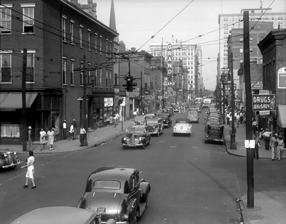
In the early 20th century, the western edge of Downtown Louisville looked radically different. It was anchored by Walnut Street (now Muhammad Ali), which functioned as a sort of central business district/corridor for much of Louisville’s African American population. The corridor did not have strict borders, but it generally is considered to have extended from Sixth Street to Thirteenth Street, bridging the gap between Downtown and Russell. The Walnut district was essentially wiped out in the 60s and 70s, as Urban Renewal programs sought to replace the area’s “blight” with public housing and a downtown civic district.
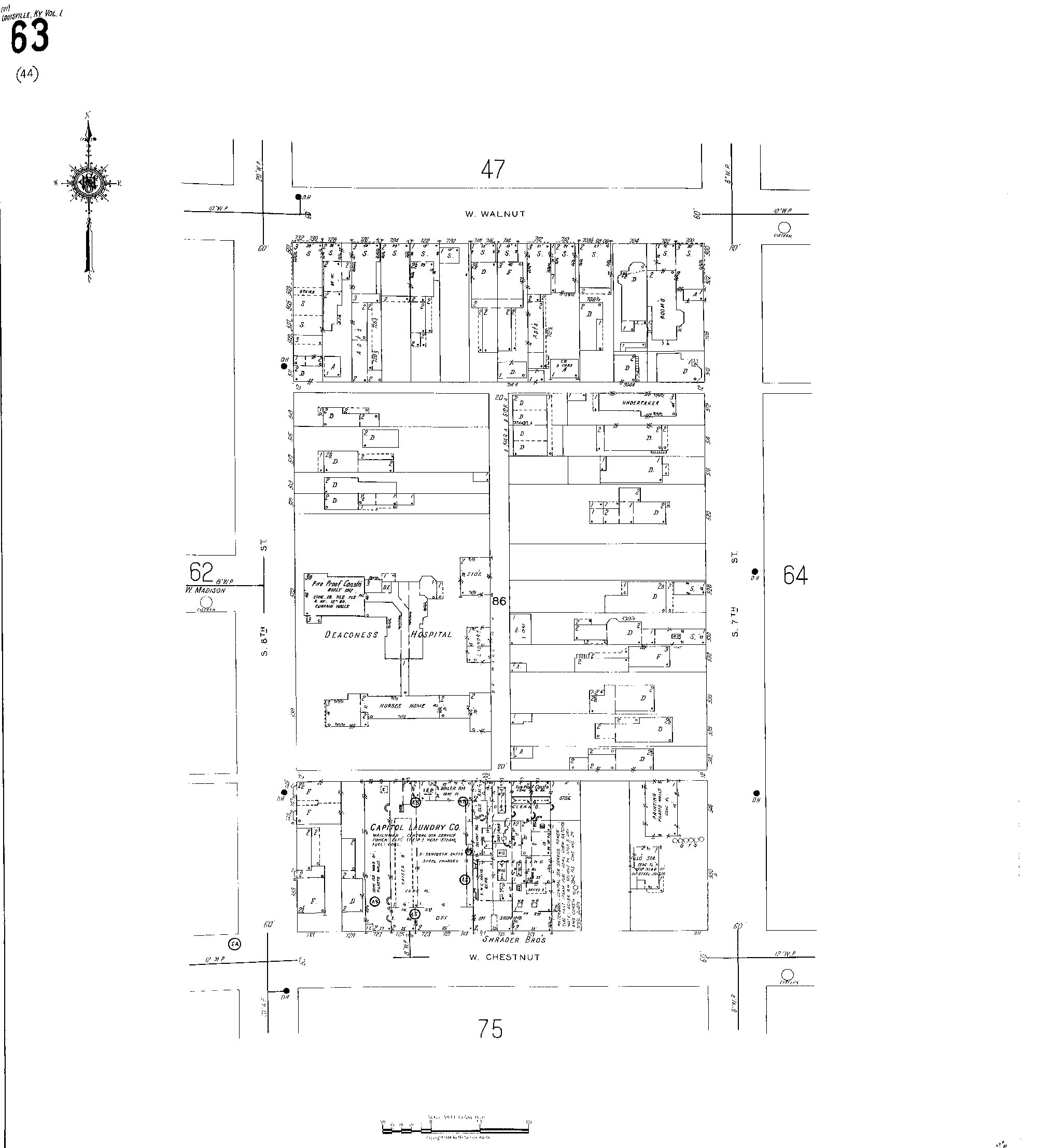
There exists little remnant of Walnut today, and there are not many resources that cover the physical imprint it had on Louisville. To help fill that gap, we can take Sanborn fire insurance maps and use them to map out the building footprints of what the corridor used to be. For this mapping project, Sanborn maps from 1940 are used. Since much of the corridor was demolished as a consequence of urban renewal, we can also utilize the recently digitized photos from the Urban Renewal Commission to get imagery of some of the structures and businesses along the street. This will paint the most thorough picture of how the corridor existed in the past.
Below is an application that allows you to use a slider to compare the 1940 and 2025 building footprints. You can also click on some buildings to see imagery of how they looked when they were still standing.
View in another window here.
In 2025, the Walnut corridor (extending about two blocks away from Walnut) contains approximately 191 structures. Many of these are part of the Beecher Terrace housing development. In 1940, the same extent had approximately 1350 structures. A fair amount of these were sheds and personal garages, but if we even assumed half were these secondary structures, then Walnut has lost over half of its building density since 1940. This change would be even more extreme if you went further back in time, as Beecher Terrace had started construction by 1940. If the portion of Beecher Terrace that had already been constructed involved the demolition of a similar number of structures as its future addition south of Walnut, then there were around 500 structures in the area that had already been demolished by 1940.
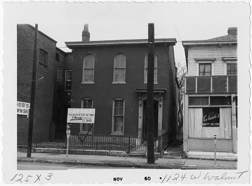
While Urban Renewal was framed as removing blight and dilapidated buildings, many of the structures demolished were large, historic, and (at least externally) in good condition. One of our past field notes articles covered the loss of some of these structures, such as the Old National/B.F. Keith Theatre. One of the largest in the city and a black theater during the segregation era, it was torn down less than 50 years after its construction to be replaced with a parking lot. Much of the housing stock that was demolished would not look out of place today in neighborhoods like Old Louisville.
Within the relatively limited scope of our research, we were able to find 27 commercial buildings placed directly on the corridor. Many of these buildings had multiple businesses, meaning there were likely at least 30 or so businesses along this one mile stretch. Today, the corridor has only a single service/customer-facing business in River City Bank. Almost every single structure that existed in 1940 has been demolished, and those that remain are largely offices, housing projects, or underutilized historic structures intermingled with parking lots. Many amenities that remain scarce or non-existent downtown today existed in multiples along the corridor: movie theaters, barbershops, supermarkets, and more. Walnut functioned as a lively central business district for African Americans in Louisville; today, there is effectively zero remnant of it. Even River City Bank hides its original structure behind a facade.
A major component of walkability is the intermingling of different uses. Old pictures of the Walnut corridor often show a streetscape densely populated with residents, workers, and visitors; today the corridor is largely empty, with its uses partitioned away from one another. West of Eighth Street mostly lies housing, to the east of Eighth mostly lies parking lots and offices. This creates an environment that is often more populated more by cars than by human beings, and as walkability is extinguished in the area, so are the health [2] [3] and economic benefits associated with it.
It should be noted that Walnut is not unique in its lost density, much of Louisville’s urban core was historically much denser. This meant more businesses, third places, and more efficient public transportation.The barren, often empty corridors that exist in parts of city are not the historic norm. Only a couple generations separate many of us from a radically different Louisville, both in the past and future.
The Sanborn maps are some of the most comprehensive maps of cities in the early 20th century, and would allow for this map to be iterated on with a 3D version in the future, as the maps include the number of stories many structures have. This work may be conducted in the future to create a more elaborate model of the Walnut district and add even more businesses.